
Gracias por apoyar a este sitio ❤️
Haz una donación
Haz una donación
Mapa topográfico Cairn of Claise
Haga clic en el mapa para ver la altitud.
Gracias por apoyar a este sitio ❤️
Haz una donación
Haz una donación
Cairn of Claise
It has an elevation of 1,063.1 m (3,488 ft) and a prominence of 118.9 m (390 ft) and is a Munro.
Gracias por apoyar a este sitio ❤️
Haz una donación
Haz una donación
Acerca de este mapa
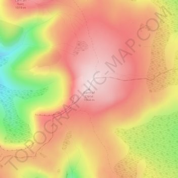
Nombre: Mapa topográfico Cairn of Claise, altitud, relieve.
Lugar: Cairn of Claise, Angus, Scotland, United Kingdom (56.89413 -3.33868 56.89423 -3.33858)
Altitud media: 919 m
Altitud mínima: 680 m
Altitud máxima: 1 060 m
Gracias por apoyar a este sitio ❤️
Haz una donación
Haz una donación
Otros mapas topográficos
Haga clic en un mapa para ver su topografía, su altitud y su relieve.
Gracias por apoyar a este sitio ❤️
Haz una donación
Haz una donación
Gracias por apoyar a este sitio ❤️
Haz una donación
Haz una donación
Gracias por apoyar a este sitio ❤️
Haz una donación
Haz una donación
Gracias por apoyar a este sitio ❤️
Haz una donación
Haz una donación