
Gracias por apoyar a este sitio ❤️
Haz una donación
Haz una donación
Mapa topográfico Vijayawada
Haga clic en el mapa para ver la altitud.
Gracias por apoyar a este sitio ❤️
Haz una donación
Haz una donación
Vijayawada
Vijayawada lies on the banks of Krishna river, covered by hills and canals. and at an altitude of 11 m (36 ft) above sea level. Three canals originating from the north side of the Prakasam Barrage reservoir — Eluru, Bandar, and Ryves — flow through the city.
Gracias por apoyar a este sitio ❤️
Haz una donación
Haz una donación
Acerca de este mapa
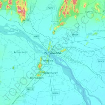
Nombre: Mapa topográfico Vijayawada, altitud, relieve.
Lugar: Vijayawada, NTR, Andhra Pradesh, 520001, India (16.35153 80.45605 16.67153 80.77605)
Altitud media: 37 m
Altitud mínima: 7 m
Altitud máxima: 448 m
Gracias por apoyar a este sitio ❤️
Haz una donación
Haz una donación