
Haz una donación
Mapa topográfico White Lake Charter Township
Haga clic en el mapa para ver la altitud.
Haz una donación
Acerca de este mapa
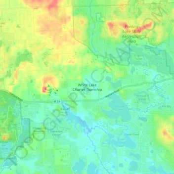
Nombre: Mapa topográfico White Lake Charter Township, altitud, relieve.
Altitud media: 302 m
Altitud mínima: 277 m
Altitud máxima: 355 m
Haz una donación
Otros mapas topográficos
Haga clic en un mapa para ver su topografía, su altitud y su relieve.
Highland State Recreation Area
United States > Michigan > Oakland County > Highland
West of Duck Lake Road in Highland State Recreation Area, a group of small moraines are locally called "mountains"—the highest elevation in the park, Mount Kanzer, is 1,150 feet (350 m) above sea level. The highland for which this recreation area is named is this group of moraines.
Altitud media: 302 m
Veterans Park
United States > Michigan > Oakland County > Highland Charter Township
Altitud media: 310 m
Haz una donación
Waterbury Lake
United States > Michigan > Oakland County > Highland Charter Township
Altitud media: 308 m
Haz una donación
Haz una donación
Haz una donación
Carpenter Lake Nature Preserve
United States > Michigan > Oakland County > Southfield
Altitud media: 207 m
Haz una donación
Loon Lake
United States > Michigan > Oakland County > Waterford Township > Clintonville
Altitud media: 294 m