
Haz una donación
Mapa topográfico Mohican Lake
Haga clic en el mapa para ver la altitud.
Haz una donación
Acerca de este mapa
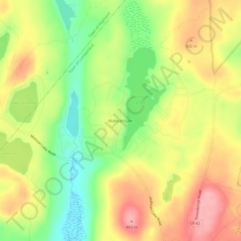
Nombre: Mapa topográfico Mohican Lake, altitud, relieve.
Altitud media: 402 m
Altitud mínima: 341 m
Altitud máxima: 459 m
Haz una donación
Otros mapas topográficos
Haga clic en un mapa para ver su topografía, su altitud y su relieve.
Town of Mamakating
United States > New York > Sullivan County
The highest elevation in the town is 1,648 feet (502 m), near the junction of Mamakating Avenue and Park Road in the Mamakating Park Historic District. The lowest elevation is 340 feet (100 m), at the tripoint with Orange and Ulster counties where the Bush Kill drains into the Shawangunkill.
Altitud media: 316 m
Shawangunk Ridge
United States > New York > Sullivan County
The ridge is widest (7.5 miles (12.1 km)) near the northern end and narrow in the middle (1.25 miles (2.01 km)), with a maximum elevation of 2,289 feet (698 m) near Lake Maratanza. The ridge rises above a broad, high plain which stretches to the Hudson River to the east. On the west the low foothills of the…
Altitud media: 256 m
Haz una donación
Town of Fremont
United States > New York > Sullivan County
The climate of the town is typical of the interior northeast. Made up of hills of about 2,000 ft. in elevation and valleys under 1,000 ft. The majority of the town is forested with open fields scattered about.
Altitud media: 484 m
Haz una donación
Grahamsville
United States > New York > Sullivan County > Town of Neversink
Grahamsville is located at latitude 41.848 and longitude -74.548. The elevation is 968 feet. Grahamsville is in the Eastern Time Zone.
Altitud media: 397 m
Haz una donación
Evens Lake
United States > New York > Sullivan County > Town of Fallsburg > Loch Sheldrake
Altitud media: 443 m
Haz una donación