
Mapa topográfico Le Dorlett
Mapa interactivo
Haga clic en el mapa para ver la altitud.
Acerca de este mapa
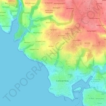
Nombre: Mapa topográfico Le Dorlett, altitud, relieve.
Altitud media: 30 m
Altitud mínima: 0 m
Altitud máxima: 80 m
Otros mapas topográficos
Haga clic en un mapa para ver su topografía, su altitud y su relieve.
Poulyoud
France > Bretagne > Finistère > Concarneau
Poulyoud, Concarneau, Quimper, Finistère, Bretagne, France métropolitaine, 29900, France
Altitud media: 22 m
Landan Creis
France > Bretagne > Finistère > Concarneau
Landan Creis, Concarneau, Quimper, Finistère, Bretagne, France métropolitaine, 29900, France
Altitud media: 24 m
La Maison Blanche
France > Bretagne > Finistère > Concarneau > Le Zins
La Maison Blanche, Le Zins, Concarneau, Quimper, Finistère, Bretagne, France métropolitaine, 29900, France
Altitud media: 44 m
Kersimonou
France > Bretagne > Finistère > Concarneau
Kersimonou, Concarneau, Quimper, Finistère, Bretagne, France métropolitaine, 29900, France
Altitud media: 89 m
Kercorre
France > Bretagne > Finistère > Concarneau
Kercorre, Concarneau, Quimper, Finistère, Bretagne, France métropolitaine, 29900, France
Altitud media: 28 m
Toulmengleuz
France > Bretagne > Finistère > Concarneau
Toulmengleuz, Concarneau, Quimper, Finistère, Bretagne, France métropolitaine, 29900, France
Altitud media: 28 m
Kerangall
France > Bretagne > Finistère > Concarneau
Kerangall, Concarneau, Quimper, Finistère, Bretagne, France métropolitaine, 29900, France
Altitud media: 12 m
Le Mine
France > Bretagne > Finistère > Concarneau
Le Mine, Concarneau, Quimper, Finistère, Bretagne, France métropolitaine, 29900, France
Altitud media: 12 m
Stang Couls
France > Bretagne > Finistère > Concarneau
Stang Couls, Concarneau, Quimper, Finistère, Bretagne, France métropolitaine, 29900, France
Altitud media: 53 m
Le Cabellou
France > Bretagne > Finistère > Concarneau > Le Cabellou
Le Cabellou, Concarneau, Quimper, Finistère, Bretagne, France métropolitaine, 29900, France
Altitud media: 7 m
Les Hauts du Cabelou
France > Bretagne > Finistère > Concarneau > Les Hauts du Cabelou
Les Hauts du Cabelou, Concarneau, Quimper, Finistère, Bretagne, France métropolitaine, 29900, France
Altitud media: 16 m
Coat Pin
France > Bretagne > Finistère > Concarneau
Coat Pin, Concarneau, Quimper, Finistère, Bretagne, France métropolitaine, 29900, France
Altitud media: 12 m
La Villeneuve
France > Bretagne > Finistère > Concarneau
La Villeneuve, Concarneau, Quimper, Finistère, Bretagne, France métropolitaine, 29900, France
Altitud media: 50 m
Lanadan Creiz
France > Bretagne > Finistère > Concarneau
Lanadan Creiz, Concarneau, Quimper, Finistère, Bretagne, France métropolitaine, 29900, France
Altitud media: 32 m
Le Rouz
France > Bretagne > Finistère > Concarneau
Le Rouz, Concarneau, Quimper, Finistère, Bretagne, France métropolitaine, 29900, France
Altitud media: 17 m
Stang Noblet
France > Bretagne > Finistère > Concarneau
Stang Noblet, Concarneau, Quimper, Finistère, Bretagne, France métropolitaine, 29900, France
Altitud media: 41 m
Le Zins
France > Bretagne > Finistère > Concarneau
Le Zins, Concarneau, Quimper, Finistère, Bretagne, France métropolitaine, 29900, France
Altitud media: 47 m