
Mapa topográfico Saint Barthélemy
Mapa interactivo
Haga clic en el mapa para ver la altitud.
Acerca de este mapa
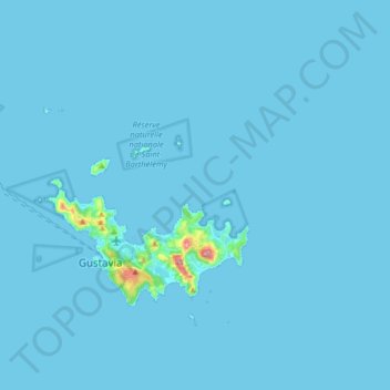
Nombre: Mapa topográfico Saint Barthélemy, altitud, relieve.
Lugar: Saint Barthélemy, 97133, France (17.87082 -62.95112 17.97410 -62.78903)
Altitud media: 4 m
Altitud mínima: 0 m
Altitud máxima: 246 m
Morne de Vitet, 286 metres (938 feet) in height, is the highest peak on the island. Hills and valleys of varying topography cover the rest of the island. Notable are Morne Rouge, Morne Criquet, Morne de Grand Fond, Morne de Dépoudré and Morne Lurin. The largest bodies of water on the island are Étang de Saint-Jean, Grande Saline, Grand Étang, and Petit Étang.