
Haz una donación
Mapa topográfico Glacier County
Haga clic en el mapa para ver la altitud.
Haz una donación
Acerca de este mapa
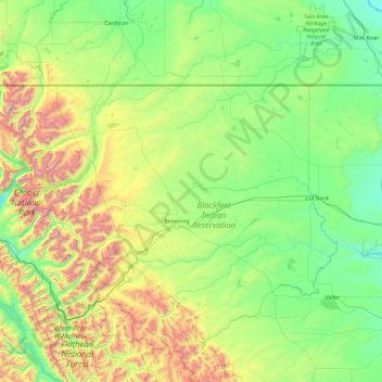
Nombre: Mapa topográfico Glacier County, altitud, relieve.
Lugar: Glacier County, Montana, United States (48.30740 -114.06821 48.99887 -112.18473)
Altitud media: 1 416 m
Altitud mínima: 946 m
Altitud máxima: 3 135 m
Haz una donación
Otros mapas topográficos
Haga clic en un mapa para ver su topografía, su altitud y su relieve.
Kalispell
United States > Montana > Flathead County > Kalispell
Kalispell is located at 48°11′52″N 114°18′58″W / 48.19778°N 114.31611°W / 48.19778; -114.31611 (48.197801, −114.316068), at an elevation of 2,956 feet (901 m).
Altitud media: 1 055 m
Bozeman
United States > Montana > Gallatin County > Bozeman
Bozeman is located at an elevation of 4,820 feet (1,470 m). The Bridger Mountains are to the north-northeast, the Tobacco Root Mountains to the west-south-west, the Big Belt Mountains and Horseshoe Hills to the northwest, the Hyalite Peaks of the northern Gallatin Range to the south and the Spanish Peaks of…
Altitud media: 1 679 m