
Mapa topográfico Folkestone
Mapa interactivo
Haga clic en el mapa para ver la altitud.
Acerca de este mapa
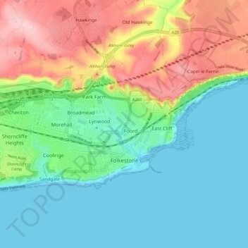
Nombre: Mapa topográfico Folkestone, altitud, relieve.
Lugar: Folkestone, Folkestone and Hythe, Kent, Angleterre, Royaume-Uni (51.07173 1.11929 51.10519 1.22124)
Altitud media: 62 m
Altitud mínima: 0 m
Altitud máxima: 189 m
Otros mapas topográficos
Haga clic en un mapa para ver su topografía, su altitud y su relieve.
Dymchurch
Royaume-Uni > Angleterre > Kent > Folkestone and Hythe
Dymchurch, Folkestone and Hythe, Kent, Angleterre, Royaume-Uni
Altitud media: 1 m
Postling
Royaume-Uni > Angleterre > Kent > Folkestone and Hythe
Postling, Folkestone and Hythe, Kent, Angleterre, Royaume-Uni
Altitud media: 112 m