
Gracias por apoyar a este sitio ❤️
Haz una donación
Haz una donación
Mapa topográfico Shenandoah National Park
Haga clic en el mapa para ver la altitud.
Gracias por apoyar a este sitio ❤️
Haz una donación
Haz una donación
Shenandoah National Park
Shenandoah National Park lies along the Blue Ridge Mountains in north-central Virginia. These mountains form a distinct highland rising to elevations above 4,000 feet (1,200 m). Local topographic relief between the Blue Ridge Mountains and Shenandoah Valley exceeds 3,000 feet (900 m) at some locations. The crest of the range divides the Shenandoah River drainage basin, part of the Potomac River drainage, on the west side, from the James and Rappahannock River drainage basins on the east side.
Gracias por apoyar a este sitio ❤️
Haz una donación
Haz una donación
Acerca de este mapa
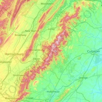
Nombre: Mapa topográfico Shenandoah National Park, altitud, relieve.
Altitud media: 335 m
Altitud mínima: 72 m
Altitud máxima: 1 214 m
Gracias por apoyar a este sitio ❤️
Haz una donación
Haz una donación
Otros mapas topográficos
Haga clic en un mapa para ver su topografía, su altitud y su relieve.