
Mapa topográfico Gundelshausen
Mapa interactivo
Haga clic en el mapa para ver la altitud.
Acerca de este mapa
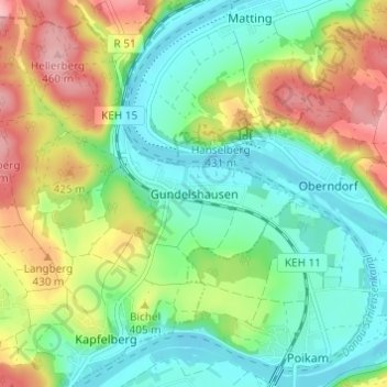
Nombre: Mapa topográfico Gundelshausen, altitud, relieve.
Lugar: Gundelshausen, Kelheim, Landkreis Kelheim, Bayern, Deutschland (48.92630 11.97781 48.96630 12.01781)
Altitud media: 382 m
Altitud mínima: 333 m
Altitud máxima: 468 m
Otros mapas topográficos
Haga clic en un mapa para ver su topografía, su altitud y su relieve.
93309
Deutschland > Bayern > Landkreis Kelheim > Kelheim
93309, Kelheim, Landkreis Kelheim, Bayern, Deutschland
Altitud media: 405 m
Großberghofen
Deutschland > Bayern > Landkreis Kelheim > Kelheim
Großberghofen, Kelheim, Landkreis Kelheim, Bayern, 93309, Deutschland
Altitud media: 398 m
Weltenburg
Deutschland > Bayern > Landkreis Kelheim > Kelheim
Weltenburg, Kelheim, Landkreis Kelheim, Bayern, Deutschland
Altitud media: 411 m
Lohstadt
Deutschland > Bayern > Landkreis Kelheim > Kelheim > Gundelshausen > Lohstadt
Lohstadt, Gundelshausen, Kelheim, Landkreis Kelheim, Bayern, Deutschland
Altitud media: 399 m
Staubing
Deutschland > Bayern > Landkreis Kelheim > Kelheim
Staubing, Kelheim, Landkreis Kelheim, Bayern, 93343, Deutschland
Altitud media: 395 m
Hienheimer Forst
Deutschland > Bayern > Landkreis Kelheim > Kelheim
Hienheimer Forst, Kelheim, Landkreis Kelheim, Bayern, Deutschland
Altitud media: 426 m