
Haz una donación
Mapa topográfico Hillsborough
Haga clic en el mapa para ver la altitud.
Haz una donación
Hillsborough
According to the United States Census Bureau, the town has a total area of 6.2 square miles (16 km2), all of it land. The area's considerably winding, hilly topography, and impossibility of a grid layout make Hillsborough notoriously challenging to navigate. Many lots include fairly steep slopes, particularly the western side of the town, with the landscape generally flattening to the east as it descends from the 280 freeway to El Camino Real and the towns of Burlingame and San Mateo.
Haz una donación
Acerca de este mapa
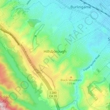
Nombre: Mapa topográfico Hillsborough, altitud, relieve.
Lugar: Hillsborough, San Mateo County, California, United States (37.53005 -122.39343 37.58085 -122.32838)
Altitud media: 100 m
Altitud mínima: 3 m
Altitud máxima: 331 m
Haz una donación
Otros mapas topográficos
Haga clic en un mapa para ver su topografía, su altitud y su relieve.
San Carlos
United States > California > San Mateo County > San Carlos > San Carlos
Altitud media: 47 m