
Mapa topográfico Shreveport
Mapa interactivo
Haga clic en el mapa para ver la altitud.
Acerca de este mapa
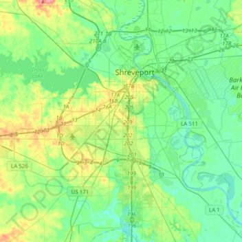
Nombre: Mapa topográfico Shreveport, altitud, relieve.
Lugar: Shreveport, Caddo Parish, Louisiana, United States (32.33269 -93.94785 32.58987 -93.67972)
Altitud media: 58 m
Altitud mínima: 38 m
Altitud máxima: 112 m
Shreveport is the parish seat of Caddo Parish. Portions of the city extend into neighboring Bossier Parish, bordering Bossier City. Shreveport sits on a low elevation overlooking the Red River. Western and northern portions of Shreveport have an elevation over 253 feet (77 m) above sea level. Pine forests, cotton fields, wetlands, and waterways mark the outskirts of the city. According to the United States Census Bureau in 2010, the city had a total area of 122.35 sq mi (316.88 km2), of which 107.14 sq mi (277.48 km2) is land and 15.21 sq mi (39.40 km2) is water.
Otros mapas topográficos
Haga clic en un mapa para ver su topografía, su altitud y su relieve.
Oil City
United States > Louisiana > Caddo Parish
Oil City, Caddo Parish, Louisiana, 71061, United States
Altitud media: 57 m
Southdowns
United States > Louisiana > Caddo Parish > Shreveport
Southdowns, Shreveport, Caddo Parish, Louisiana, 71118, United States
Altitud media: 58 m
University Park
United States > Louisiana > Caddo Parish > Shreveport
University Park, Shreveport, Caddo Parish, Louisiana, 71106, United States
Altitud media: 50 m
Cynthia Park
United States > Louisiana > Caddo Parish > Shreveport > Cynthia Park
Cynthia Park, Shreveport, Caddo Parish, Louisiana, 71109, United States
Altitud media: 71 m
Hosston
United States > Louisiana > Caddo Parish > Hosston
Hosston, Caddo Parish, Louisiana, 71043, United States
Altitud media: 63 m