
Mapa topográfico Macerata
Mapa interactivo
Haga clic en el mapa para ver la altitud.
Acerca de este mapa
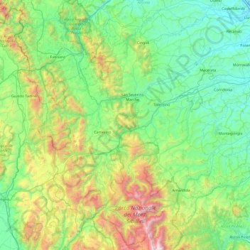
Nombre: Mapa topográfico Macerata, altitud, relieve.
Lugar: Macerata, Marche, Italy (42.83185 12.82965 43.47421 13.74328)
Altitud media: 562 m
Altitud mínima: 4 m
Altitud máxima: 2 436 m
Typically hilly, the climate is both Mediterranean and continental. The Adriatic Sea, which is approximately 30 kilometres (19 mi) away, and particularly the Apennine Mountains influence the weather. The elevation of Macerata is approximately 315 metres (1,033 ft) above sea level, so winter is particularly rainy and the snow is not so frequent and plentiful. Balkanic and northwestern perturbations may cause snow. Middle seasons are variable, and late snowfall and frost may occur during April. October is neither warm nor very cold. Summer is rather sunny, and sometimes the thermometer reaches 40 °C (104 °F). Garbino is the cause, a hot wind from the hinterland. Summer thunderstorms are frequent in August during the evening, when the weather becomes quite unstable.
Otros mapas topográficos
Haga clic en un mapa para ver su topografía, su altitud y su relieve.
San Mariano
Italy > Marche > Ancona > Arcevia
San Mariano, Arcevia, Ancona, Marche, 60011, Italy
Altitud media: 290 m
Gradara
Italy > Marche > Pesaro e Urbino > Gradara
Gradara, Pesaro e Urbino, Marche, 61012, Italy
Altitud media: 62 m
Francavilla d'Ete
Italy > Marche > Fermo > Francavilla d'Ete
Francavilla d'Ete, Fermo, Marche, Italy
Altitud media: 142 m