
Haz una donación
Mapa topográfico Huásabas
Haga clic en el mapa para ver la altitud.
Haz una donación
Acerca de este mapa
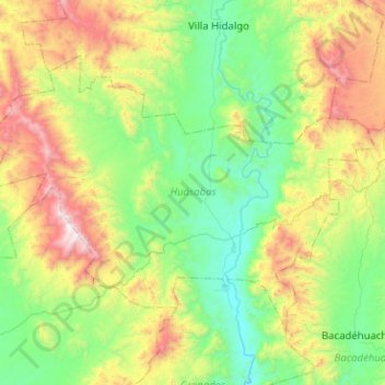
Nombre: Mapa topográfico Huásabas, altitud, relieve.
Lugar: Huásabas, Sonora, Mexico (29.81467 -109.62150 30.12729 -109.11565)
Altitud media: 1 031 m
Altitud mínima: 502 m
Altitud máxima: 2 319 m
Haz una donación
Otros mapas topográficos
Haga clic en un mapa para ver su topografía, su altitud y su relieve.
Rocky Point
Mexico > Sonora > Rocky Point
The city of Puerto Peñasco (Rocky Point) is found in the northwest of the Mexican state of Sonora, a state that is located directly to the south of the U.S. state of Arizona. It is located on the eastern coast of the Gulf of California approximately 60 miles south of the Arizonan border, only about a…
Altitud media: 9 m
Haz una donación
Haz una donación
Hermosillo
Mexico > Sonora > Hermosillo > Hermosillo
The Cerro de la Campana mountain is one of the symbols of Hermosillo. Its summit is 350 metres (1,150 ft) above the valley floor and contains a lookout called El Caracol, which was inaugurated in 1909. There are two theories as to the origin of the mountain's name. One states that it is from a peculiar…
Altitud media: 248 m
Haz una donación
Ciudad Obregón
The city is located on the parallel 27–29' north latitude and the meridian 109-59' west longitude. With an altitude above sea level of 40.8 m (134 ft) in the city center.
Altitud media: 59 m