
Haz una donación
Mapa topográfico Cline River
Haga clic en el mapa para ver la altitud.
Haz una donación
Acerca de este mapa
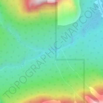
Nombre: Mapa topográfico Cline River, altitud, relieve.
Lugar: Cline River, Clearwater County, Alberta, Canada (52.16085 -116.50553 52.16130 -116.50000)
Altitud media: 1 522 m
Altitud mínima: 1 318 m
Altitud máxima: 2 014 m
Haz una donación
Otros mapas topográficos
Haga clic en un mapa para ver su topografía, su altitud y su relieve.
Nordegg
Canada > Alberta > Clearwater County
Nordegg has a subarctic climate (Dfc) which can be considered a subalpine climate due to its altitude with locations on the same latitude having warmer climates. Summers are mild, with a few warm days sprinkled in here and there, while winters are cold and snowy.
Altitud media: 1 475 m
Haz una donación
Haz una donación
Nordegg
Canada > Alberta > Clearwater County
Nordegg has a subarctic climate (Dfc) which can be considered a subalpine climate due to its altitude with locations on the same latitude having warmer climates. Summers are mild, with a few warm days sprinkled in here and there, while winters are cold and snowy.
Altitud media: 1 475 m
Nordegg
Canada > Alberta > Clearwater County
Nordegg has a subarctic climate (Dfc) which can be considered a subalpine climate due to its altitude with locations on the same latitude having warmer climates. Summers are mild, with a few warm days sprinkled in here and there, while winters are cold and snowy.
Altitud media: 1 399 m
Haz una donación
Haz una donación