
Haz una donación
Mapa topográfico Lake Ariel
Haga clic en el mapa para ver la altitud.
Haz una donación
Acerca de este mapa
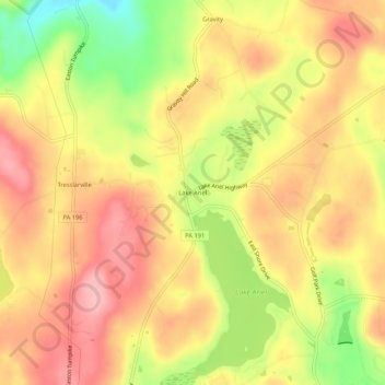
Nombre: Mapa topográfico Lake Ariel, altitud, relieve.
Altitud media: 453 m
Altitud mínima: 365 m
Altitud máxima: 510 m
Haz una donación
Otros mapas topográficos
Haga clic en un mapa para ver su topografía, su altitud y su relieve.
Haz una donación
Hawley
United States > Pennsylvania > Wayne County
Hawley is located where Middle Creek enters the Lackawaxen River, at 41°28′42″N 75°10′45″W / 41.47833°N 75.17917°W / 41.47833; -75.17917 (41.478225, -75.179154) at an elevation of 1,033 feet (314.9 m). Hawley students attend Wallenpaupack Areas Schools, with high, middle, and primary…
Altitud media: 334 m
Haz una donación
Haz una donación
Haz una donación