
Mapa topográfico Monte Rosa
Mapa interactivo
Haga clic en el mapa para ver la altitud.
Monte Rosa
The peak is distinguished by the name Dufourspitze (in German, lit. Dufour Peak; French: Pointe Dufour, Italian: Punta Dufour). This replaced the former name Höchste Spitze (English: Highest Peak) that was indicated on the Swiss maps before the Federal Council, on January 28, 1863, decided to rename the mountain in honor of Guillaume-Henri Dufour. Dufour was a Swiss engineer, topographer, co-founder of the Red Cross and army general who led the Sonderbund campaign. This decision followed the completion of the Dufour Map, a series of military topographical maps created under the command of Dufour.
Acerca de este mapa
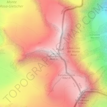
Nombre: Mapa topográfico Monte Rosa, altitud, relieve.
Lugar: Monte Rosa, Zermatt, Visp, Wallis, 3920, Switzerland (45.93686 7.86670 45.93696 7.86680)
Altitud media: 4 033 m
Altitud mínima: 3 037 m
Altitud máxima: 4 619 m
Otros mapas topográficos
Haga clic en un mapa para ver su topografía, su altitud y su relieve.