
Mapa topográfico Palmas
Mapa interactivo
Haga clic en el mapa para ver la altitud.
Acerca de este mapa
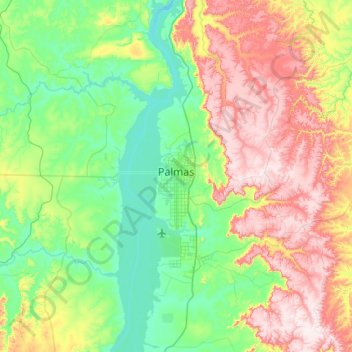
Nombre: Mapa topográfico Palmas, altitud, relieve.
Altitud media: 367 m
Altitud mínima: 189 m
Altitud máxima: 711 m
Palmas is located at the state's geographic centre at an average altitude of 230 m (755 ft). The city is located between the Serra do Lajeado hills on the east and the Tocantins River on the west. Palmas has a metropolitan area with 471,639 inhabitants.
Otros mapas topográficos
Haga clic en un mapa para ver su topografía, su altitud y su relieve.
Santa Maria do Tocantins
Brazil > Tocantins > Santa Maria do Tocantins
Santa Maria do Tocantins, Microrregião de Porto Nacional, Mesorregião Oriental do Tocantins, Tocantins, North Region, Brazil
Altitud media: 264 m