
Mapa topográfico Pfäfers
Mapa interactivo
Haga clic en el mapa para ver la altitud.
Acerca de este mapa
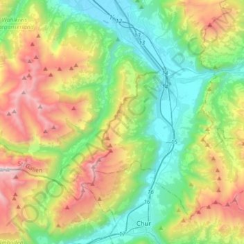
Nombre: Mapa topográfico Pfäfers, altitud, relieve.
Lugar: Pfäfers, Wahlkreis Sarganserland, Sankt Gallen, Switzerland (46.87289 9.24882 46.99710 9.53269)
Altitud media: 1 355 m
Altitud mínima: 484 m
Altitud máxima: 3 092 m
The municipality is located in the Sarganserland Wahlkreis. It stretches from the Taminatal south to the Kunkelspass and to the west into the high Calfeisen valley. The municipality has some of the largest elevation differences of any municipality (Tamina canyon 693 m (2,274 ft), Ringelspitz 3,247 m (10,653 ft)). It consists of the village of Pfäfers at the mouth of the Tamina Valley on a plateau above the Rhine river, the villages of Valens, Vasön and Vättis as well as the hamlets of St. Margrethenberg and Vadura.