
Mapa topográfico Neuchâtel
Mapa interactivo
Haga clic en el mapa para ver la altitud.
Acerca de este mapa
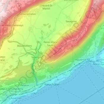
Nombre: Mapa topográfico Neuchâtel, altitud, relieve.
Lugar: Neuchâtel, Switzerland (46.97784 6.84515 47.06382 6.99178)
Altitud media: 722 m
Altitud mínima: 422 m
Altitud máxima: 1 359 m
Otros mapas topográficos
Haga clic en un mapa para ver su topografía, su altitud y su relieve.
La Roche
Switzerland > Neuchâtel > La Sagne > La Roche
La Roche, La Sagne, Neuchâtel, 2314, Switzerland
Altitud media: 1 115 m
La Ronde
Switzerland > Neuchâtel > Bernese Jura administrative district > La Chaux-de-Fonds
La Ronde, La Chaux-de-Fonds, Bernese Jura administrative district, Bernese Jura administrative region, Neuchâtel, 2336, Switzerland
Altitud media: 807 m
Lake Neuchâtel
Switzerland > Neuchâtel > Seeland administrative district
Lake Neuchâtel, Seeland administrative district, Seeland administrative region, Neuchâtel, Switzerland
Altitud media: 658 m
Milvignes
Switzerland > Neuchâtel > Milvignes
Milvignes, District de Boudry, Neuchâtel, Switzerland
Altitud media: 573 m
La Chaux-de-Fonds
Switzerland > Neuchâtel > La Chaux-de-Fonds
La Chaux-de-Fonds, District de La Chaux-de-Fonds, Neuchâtel, Switzerland
Altitud media: 1 039 m