
Mapa topográfico Pully
Mapa interactivo
Haga clic en el mapa para ver la altitud.
Acerca de este mapa
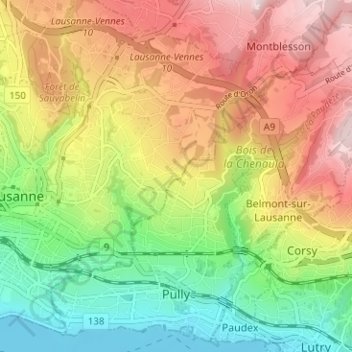
Nombre: Mapa topográfico Pully, altitud, relieve.
Lugar: Pully, District de Lavaux-Oron, Vaud, Switzerland (46.50392 6.63934 46.54464 6.70218)
Altitud media: 578 m
Altitud mínima: 369 m
Altitud máxima: 818 m
The municipality stretches from Lake Geneva to the Jorat and includes the peak of Monts-de-Pully at an elevation of 806 m (2,644 ft). It consists of the village section of Chamblandes, La Perraudettaz, Port, Rochettaz and La Rosiaz.
Otros mapas topográficos
Haga clic en un mapa para ver su topografía, su altitud y su relieve.
Chexbres
Switzerland > Vaud > District de Lavaux-Oron > Chexbres
Chexbres, District de Lavaux-Oron, Vaud, 1071, Switzerland
Altitud media: 579 m