
Mapa topográfico Iron Bridge
Haga clic en el mapa para ver la altitud.
Acerca de este mapa
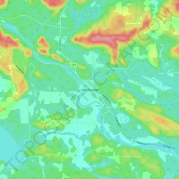
Nombre: Mapa topográfico Iron Bridge, altitud, relieve.
Altitud media: 200 m
Altitud mínima: 172 m
Altitud máxima: 270 m
Otros mapas topográficos
Haga clic en un mapa para ver su topografía, su altitud y su relieve.
Lucille Lake;Wood Creek
Canada > Ontario > Algoma District > Unorganized North Algoma
Altitud media: 441 m
St. Joseph Island
Canada > Ontario > Algoma District > Jocelyn Township
Its highest point, known colloquially and by surveyors as "the Mountain", is near the centre of the island near Carterton with an elevation of 345.6 m, which is about 169 m above Lake Huron.
Altitud media: 196 m
Kimiwan Creek;Kimiwan Lakes
Canada > Ontario > Algoma District > Unorganized North Algoma
Altitud media: 442 m
Lauzon Lake
Canada > Ontario > Algoma District > The North Shore Township > Algoma Mills
Altitud media: 210 m
Kabinakagamisis Lake
Canada > Ontario > Algoma District > Unorganized North Algoma
Altitud media: 324 m
St. Joseph Island
Canada > Ontario > Algoma District > Jocelyn Township
Its highest point, known colloquially and by surveyors as "the Mountain", is near the centre of the island near Carterton with an elevation of 345.6 m, which is about 169 m above Lake Huron.
Altitud media: 196 m