
Mapa topográfico Vallorbe
Mapa interactivo
Haga clic en el mapa para ver la altitud.
Acerca de este mapa
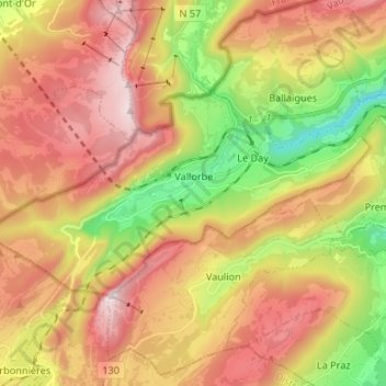
Nombre: Mapa topográfico Vallorbe, altitud, relieve.
Lugar: Vallorbe, District du Jura-Nord vaudois, Vaud, 1337, Switzerland (46.68399 6.30727 46.73189 6.43979)
Altitud media: 1 057 m
Altitud mínima: 605 m
Altitud máxima: 1 478 m
The municipality is located on the Swiss-French border. It is surrounded on three sides with mountains and reaches from 610 to 1,480 m (2,000 to 4,860 ft) in elevation. On the east side, the valley opens up due to the Jougnenaz and Orbe rivers. It includes the hamlets of Le Day, Le Creux and Bellevue.