
Mapa topográfico Veghel
Mapa interactivo
Haga clic en el mapa para ver la altitud.
Acerca de este mapa
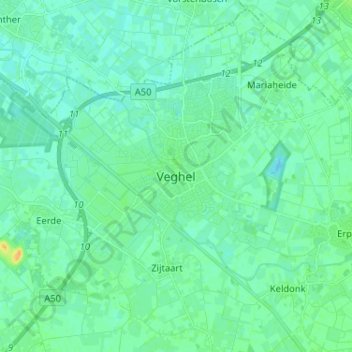
Nombre: Mapa topográfico Veghel, altitud, relieve.
Lugar: Veghel, Noord-Brabant, Nederland, 5461KN, Nederland (51.57346 5.50465 51.65346 5.58465)
Altitud media: 11 m
Altitud mínima: 5 m
Altitud máxima: 29 m
Otros mapas topográficos
Haga clic en un mapa para ver su topografía, su altitud y su relieve.
Havelt
Nederland > Noord-Brabant > Veghel > Zijtaart
Havelt, Zijtaart, Veghel, Meierijstad, Noord-Brabant, Nederland, 5463 PC, Nederland
Altitud media: 11 m
Eerde
Nederland > Noord-Brabant > Veghel
Eerde, Veghel, Meierijstad, Noord-Brabant, Nederland, 5466 PE, Nederland
Altitud media: 11 m
Driehuizen
Nederland > Noord-Brabant > Veghel > Mariaheide
Driehuizen, Mariaheide, Veghel, Meierijstad, Noord-Brabant, Nederland, 5464 RA, Nederland
Altitud media: 10 m
Zijtaart
Nederland > Noord-Brabant > Veghel
Zijtaart, Veghel, Meierijstad, Noord-Brabant, Nederland, 5465 RE, Nederland
Altitud media: 11 m