
Haz una donación
Mapa topográfico Mount Washburn
Haga clic en el mapa para ver la altitud.
Haz una donación
Mount Washburn
Mount Washburn, elevation 10,219 feet (3,115 m), is a prominent mountain peak in the Washburn Range in Yellowstone National Park, Wyoming. The peak was named in 1870 to honor Henry D. Washburn, leader of the Washburn–Langford–Doane Expedition. The Washburn Range is one of two mountains ranges completely within the boundaries of Yellowstone.
Haz una donación
Acerca de este mapa
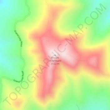
Nombre: Mapa topográfico Mount Washburn, altitud, relieve.
Lugar: Mount Washburn, Park County, Wyoming, United States (44.79751 -110.43384 44.79761 -110.43374)
Altitud media: 2 798 m
Altitud mínima: 2 503 m
Altitud máxima: 3 109 m
Haz una donación
Otros mapas topográficos
Haga clic en un mapa para ver su topografía, su altitud y su relieve.
Cody
United States > Wyoming > Park County
Cody's elevation is approximately 5016 ft (1,500 m) above sea level. The main part of the city is split across three levels, separated by about 60 feet (18 m).
Altitud media: 1 557 m
Cody
United States > Wyoming > Park County
Cody's elevation is approximately 5016 ft (1,500 m) above sea level. The main part of the city is split across three levels, separated by about 60 feet (18 m).
Altitud media: 1 557 m
Haz una donación
Cody
United States > Wyoming > Park County
Cody's elevation is approximately 4,997 feet (1,523 m) above sea level. The main part of the city is split across three levels, separated by about 60 feet (18 m).
Altitud media: 1 557 m