
Mapa topográfico Saint-Sorlin-d'Arves
Mapa interactivo
Haga clic en el mapa para ver la altitud.
Saint-Sorlin-d'Arves
It is a ski resort, part of the larger Les Sybelles area. Gaston Maulin's project of linking St Sorlin with the La Toussuire and Le Corbier ski resorts has created Les Sybelles, an area that ranks high in the list of the largest French ski areas, with over 300 kilometres of intermediate level skiing. The St Sorlin area has over 120 kilometres of pistes and is generally considered to have the best runs and be the best placed sector of the Sybelles area. With village slopes starting at 1550 metres and a current maximum lift altitude of 2620 metres there is normally good snow until the end of April but there are also plenty of strategically placed snow cannons. St Sorlin has a 16 km cross country ski trails, 4 green, 11 blue, 9 red and 2 black runs with beginners slopes in the village.
Acerca de este mapa
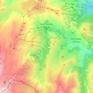
Nombre: Mapa topográfico Saint-Sorlin-d'Arves, altitud, relieve.
Altitud media: 1 998 m
Altitud mínima: 1 033 m
Altitud máxima: 3 210 m
Otros mapas topográficos
Haga clic en un mapa para ver su topografía, su altitud y su relieve.
Le Chapet
France > Auvergne-Rhône-Alpes > Savoy > La Giettaz > La Giettaz-en-Aravis
Altitud media: 1 397 m
Glacier de la Grande Casse
France > Auvergne-Rhône-Alpes > Savoy > Pralognan-la-Vanoise
Altitud media: 2 896 m
Villard-Bernon
France > Auvergne-Rhône-Alpes > Savoy > Saint-Michel-de-Maurienne
Altitud media: 1 155 m
Val Thorens
France > Auvergne-Rhône-Alpes > Savoy
Val Thorens ([val tɔʁɑ̃]) is a ski town in the Tarentaise Valley in the French Alps at an altitude of 2,300 m (7,500 ft). It is located in the commune of Saint-Martin-de-Belleville in the Savoie department. The resort forms part of the Les Trois Vallées ski area which, with over 600 km of slopes, is one…
Altitud media: 2 516 m
Les Ménuires
France > Auvergne-Rhône-Alpes > Savoy
The resort was founded in 1964 and has an altitude range of 1,850 m (6,070 ft).
Altitud media: 2 063 m
Le Chantel
France > Auvergne-Rhône-Alpes > Savoy > Bourg-Saint-Maurice > Arc 1800
Altitud media: 1 770 m
Les Fontanettes
France > Auvergne-Rhône-Alpes > Savoy > Saint-Martin-de-Belleville
Altitud media: 2 085 m
Val Thorens
France > Auvergne-Rhône-Alpes > Savoy
Val Thorens ([val tɔʁɑ̃]) is a ski town in the Tarentaise Valley in the French Alps at an altitude of 2,300 m (7,500 ft). It is located in the commune of Saint-Martin-de-Belleville in the Savoie department. The resort forms part of the Les Trois Vallées ski area which, with over 600 km of slopes, is one…
Altitud media: 2 516 m
Col de l'Iseran
France > Auvergne-Rhône-Alpes > Savoy > Bonneval-sur-Arc
On both sides of the Col de l'Iseran, mountain pass cycling milestones mark the distance to the summit, the current altitude, and the average slope in the following kilometre.
Altitud media: 2 779 m
Le Grand Morétan
France > Auvergne-Rhône-Alpes > Savoy > Saint-Colomban-des-Villards
Altitud media: 2 307 m
Saint-Jean-de-Maurienne
France > Auvergne-Rhône-Alpes > Savoy > Saint-Jean-de-Maurienne > Saint-Jean-de-Maurienne
Altitud media: 1 089 m
Plagne Centre
France > Auvergne-Rhône-Alpes > Savoy > La Plagne-Tarentaise > Plagne Centre
Altitud media: 2 078 m
Le Grand Couloir
France > Auvergne-Rhône-Alpes > Savoy > Pralognan-la-Vanoise > Le Grand Couloir
Altitud media: 1 876 m
Plagne Montalbert
France > Auvergne-Rhône-Alpes > Savoy > Aime-la-Plagne > Plagne Montalbert
Altitud media: 1 188 m
Val Thorens
France > Auvergne-Rhône-Alpes > Savoy
Val Thorens ([val tɔʁɑ̃]) is a ski town in the Tarentaise Valley in the French Alps at an altitude of 2,300 m (7,500 ft). It is located in the commune of Saint-Martin-de-Belleville in the Savoie department. The resort forms part of the Les Trois Vallées ski area which, with over 600 km of slopes, is one…
Altitud media: 2 516 m