
Haz una donación
Mapa topográfico Chambersburg
Haga clic en el mapa para ver la altitud.
Haz una donación
Chambersburg
Chambersburg is served by the Lincoln Highway, U.S. 30, between McConnellsburg and Gettysburg, Pennsylvania. U.S. 11, the Molly Pitcher Highway, passes through it between Shippensburg, Pennsylvania, and Hagerstown, Maryland. Interstate 81 skirts the borough to its east. The town lies approximately midpoint on US Route 30 between Pittsburgh and Philadelphia. The local topography reflects both flatter areas like Philadelphia and mountainous areas like Pittsburgh. Downtown Chambersburg has occasional events such as Food Truck Festival and Apple Fest.
Haz una donación
Acerca de este mapa
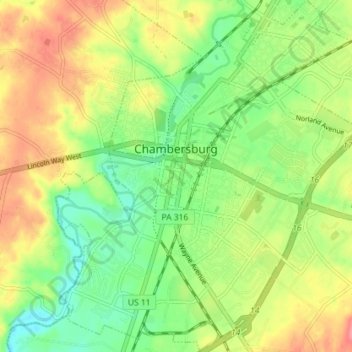
Nombre: Mapa topográfico Chambersburg, altitud, relieve.
Lugar: Chambersburg, Franklin County, Pennsylvania, United States (39.90580 -77.68568 39.96065 -77.62369)
Altitud media: 200 m
Altitud mínima: 166 m
Altitud máxima: 254 m
Haz una donación
Otros mapas topográficos
Haga clic en un mapa para ver su topografía, su altitud y su relieve.
Blue Ridge Summit
United States > Pennsylvania > Franklin County > Washington Township
Pennsylvania Route 16 passes through Blue Ridge Summit, leading east down the mountain to Emmitsburg, Maryland, and west downhill to Waynesboro. The highway elevation at Blue Ridge Summit is 1,330 feet (410 m), compared to elevations of 500 and 700 feet (150 and 210 m) east and west of the mountain,…
Altitud media: 400 m
Haz una donación
Caledonia State Park
United States > Pennsylvania > Franklin County > Greene Township
Altitud media: 367 m
Haz una donación