
Mapa topográfico Réserve naturelle du Frankenthal-Missheimle
Mapa interactivo
Haga clic en el mapa para ver la altitud.
Acerca de este mapa
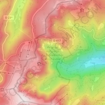
Nombre: Mapa topográfico Réserve naturelle du Frankenthal-Missheimle, altitud, relieve.
Altitud media: 1 003 m
Altitud mínima: 502 m
Altitud máxima: 1 352 m
Otros mapas topográficos
Haga clic en un mapa para ver su topografía, su altitud y su relieve.
Lac de Schiessrothried
France > Grand Est > Stosswihr
Lac de Schiessrothried, Sentier des Couloirs, Stosswihr, Colmar-Ribeauvillé, Haut-Rhin, Grand Est, France métropolitaine, 68140, France
Altitud media: 1 074 m
La Grotte Dagobert
France > Grand Est > Stosswihr
La Grotte Dagobert, Sentier des Couloirs, Stosswihr, Colmar-Ribeauvillé, Haut-Rhin, Grand Est, France métropolitaine, 68140, France
Altitud media: 1 121 m
Petit Cervin
France > Grand Est > Stosswihr
Petit Cervin, Sentier du Falimont, Stosswihr, Colmar-Ribeauvillé, Haut-Rhin, Grand Est, France métropolitaine, 68140, France
Altitud media: 1 131 m