
Gracias por apoyar a este sitio ❤️
Haz una donación
Haz una donación
Mapa topográfico Peyto Lake
Haga clic en el mapa para ver la altitud.
Gracias por apoyar a este sitio ❤️
Haz una donación
Haz una donación
Acerca de este mapa
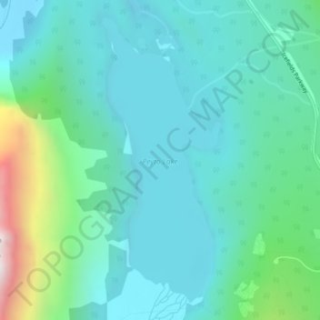
Nombre: Mapa topográfico Peyto Lake, altitud, relieve.
Lugar: Peyto Lake, Improvement District No. 9, Alberta, Kanada (51.71301 -116.52996 51.73706 -116.51393)
Altitud media: 1 996 m
Altitud mínima: 1 806 m
Altitud máxima: 2 772 m
Gracias por apoyar a este sitio ❤️
Haz una donación
Haz una donación
Otros mapas topográficos
Haga clic en un mapa para ver su topografía, su altitud y su relieve.
Lake Louise
Kanada > Alberta > Improvement District No. 9
Lake Louise ist in drei Ortsteile gegliedert. Der Hauptort, der als The Village of Lake Louise bezeichnet wird, liegt auf einer niedrigen Höhe im Talgrund. Das östlich gelegene Skigebiet Lake Louise Mountain Resort gruppiert sich mit mehreren Gondelbahnen und Sesselliften hauptsächlich am Mount Richardson…
Altitud media: 1 617 m