
Mapa topográfico Texas City
Mapa interactivo
Haga clic en el mapa para ver la altitud.
Acerca de este mapa
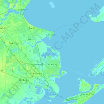
Nombre: Mapa topográfico Texas City, altitud, relieve.
Lugar: Texas City, Galveston County, Texas, United States (29.30097 -95.07828 29.56638 -94.71429)
Altitud media: 2 m
Altitud mínima: -8 m
Altitud máxima: 19 m
Officially, the elevation of Texas City is 10 feet above sea level, though some areas are even lower. It was naturally vulnerable to flooding by hurricane storm surges and heavy rainstorms.
Otros mapas topográficos
Haga clic en un mapa para ver su topografía, su altitud y su relieve.
Nadeau
United States > Texas > Galveston County > Texas City
Nadeau, Texas City, Galveston County, Texas, 77590, United States
Altitud media: 4 m
Max's Creek
United States > Texas > Galveston County > Friendswood
Max's Creek, West Ranch, Friendswood, Galveston County, Texas, United States
Altitud media: 10 m
Dickinson
United States > Texas > Galveston County
Dickinson, Galveston County, Texas, 77539, United States
Altitud media: 6 m
League City
United States > Texas > Galveston County > League City > League City
League City, Galveston County, Texas, 77573, United States
Altitud media: 7 m
League City
United States > Texas > Galveston County
League City, Galveston County, Texas, 77573, United States
Altitud media: 7 m
Kemah
United States > Texas > Galveston County > Kemah
Kemah, Galveston County, Texas, United States
Altitud media: 5 m
Galveston
United States > Texas > Galveston County > Galveston
Galveston, Galveston County, Texas, 77553, United States
Altitud media: 1 m
Galveston
United States > Texas > Galveston County
Galveston, Galveston County, Texas, United States
Altitud media: 1 m
Friendswood
United States > Texas > Galveston County
Friendswood, Galveston County, Texas, 77546, United States
Altitud media: 11 m