
Haz una donación
Mapa topográfico Gabriels
Haga clic en el mapa para ver la altitud.
Haz una donación
Acerca de este mapa
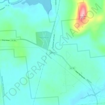
Nombre: Mapa topográfico Gabriels, altitud, relieve.
Altitud media: 530 m
Altitud mínima: 498 m
Altitud máxima: 666 m
Haz una donación
Otros mapas topográficos
Haga clic en un mapa para ver su topografía, su altitud y su relieve.
Upper Saint Regis Lake
United States > New York > Franklin County > Town of Harrietstown
Altitud media: 506 m
Haz una donación
Haz una donación
Fish Creek Pond Campground
United States > New York > Franklin County > Santa Clara
Altitud media: 488 m
Haz una donación
Lower Chateaugay Lake
United States > New York > Franklin County > Town of Ellenburg
Altitud media: 487 m
Meacham Lake
United States > New York > Franklin County
Meacham Lake is a 1,203-acre (4.87 km2) lake eight miles north of Paul Smiths in Franklin County, New York in the Adirondack Park. It is 2 miles (3.2 km) long, north to south, and 1 mile (1.6 km) wide. The lake is found at an elevation of 1,552 feet (473 m). Most of the lake is in the town of Duane; the…
Altitud media: 489 m
Haz una donación
Haz una donación