
Mapa topográfico Biel/Bienne
Mapa interactivo
Haga clic en el mapa para ver la altitud.
Acerca de este mapa
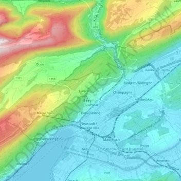
Nombre: Mapa topográfico Biel/Bienne, altitud, relieve.
Altitud media: 655 m
Altitud mínima: 423 m
Altitud máxima: 1 282 m
One funicular railways leads to the national sports center of Magglingen/Macolin on the 500 metres (1,600 ft) higher Jura mountain in the west, and the other, the Bienne-Evilard Funicular, to the city hospital and to neighbouring municipality Evilard to northwest, both above the town on the eastern range of the Jura Mountains. The high, flat pastures and wood of Magglingen/Macolin span about 7 kilometres (4.3 mi) from northeast to southwest at an altitude between 800 and 1,031 metres (2,625 and 3,383 ft). The Magglingen/Macolin Funicular often leads to sunshine while Biel/Bienne is covered by low hanging clouds.
Otros mapas topográficos
Haga clic en un mapa para ver su topografía, su altitud y su relieve.
Meinisberg
Switzerland > Bern > Biel/Bienne administrative district
Meinisberg, Biel/Bienne administrative district, Seeland administrative region, Bern, 2554, Switzerland
Altitud media: 455 m