
Mapa topográfico Springfield
Mapa interactivo
Haga clic en el mapa para ver la altitud.
Acerca de este mapa
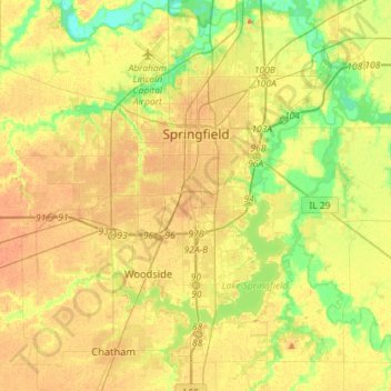
Nombre: Mapa topográfico Springfield, altitud, relieve.
Lugar: Springfield, Sangamon County, Illinois, United States (39.65366 -89.77318 39.87417 -89.56851)
Altitud media: 178 m
Altitud mínima: 152 m
Altitud máxima: 201 m
The city is at an elevation of 558 feet (170 m) above sea level. According to the 2010 census, Springfield has a total area of 65.764 square miles (170.33 km2), of which 59.48 square miles (154.05 km2) (or 90.44%) is land and 6.284 square miles (16.28 km2) (or 9.56%) is water. The city is located in the Lower Illinois River Basin, in a large area known as Till Plain. Sangamon County, and the city of Springfield, are in the Springfield Plain subsection of Till Plain. The Plain is underlain by glacial till that was deposited by a large continental ice sheet that repeatedly covered the area during the Illinoian Stage.
Otros mapas topográficos
Haga clic en un mapa para ver su topografía, su altitud y su relieve.
Williamsville
United States > Illinois > Sangamon County
Williamsville, Sangamon County, Illinois, 62693, United States
Altitud media: 177 m
Archer
United States > Illinois > Sangamon County > Springfield
Archer, Springfield, Sangamon County, Illinois, 62711, United States
Altitud media: 184 m
Spaulding
United States > Illinois > Sangamon County
Spaulding, Sangamon County, Illinois, United States
Altitud media: 171 m
Pleasant Plains
United States > Illinois > Sangamon County
Pleasant Plains, Sangamon County, Illinois, United States
Altitud media: 187 m