
Haz una donación
Mapa topográfico Mount Silex
Haga clic en el mapa para ver la altitud.
Haz una donación
Acerca de este mapa
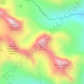
Nombre: Mapa topográfico Mount Silex, altitud, relieve.
Lugar: Mount Silex, San Juan County, Colorado, United States (37.67023 -107.54816 37.67033 -107.54806)
Altitud media: 3 678 m
Altitud mínima: 3 260 m
Altitud máxima: 4 182 m
Haz una donación
Otros mapas topográficos
Haga clic en un mapa para ver su topografía, su altitud y su relieve.
Silverton
United States > Colorado > San Juan County
According to the United States Census Bureau, the town has a total area of 0.8 square miles (2.1 km2), all of it land. Silverton is one of the highest towns in the United States, at 9,318 feet (2,840 m) above sea level. The town is located in San Juan County, the highest county in the United States, with a…
Altitud media: 2 991 m