
Gracias por apoyar a este sitio ❤️
Haz una donación
Haz una donación
Mapa topográfico Muskogee
Haga clic en el mapa para ver la altitud.
Gracias por apoyar a este sitio ❤️
Haz una donación
Haz una donación
Muskogee
Muskogee lies in the Arkansas River Valley and has a low, sea-level elevation compared to much of the rest of the state. The city is on the boundary of the oak and hickory forest region of eastern Oklahoma and the prairie, Great Plains region of northeastern Oklahoma. It is a suburban community of Tulsa.
Gracias por apoyar a este sitio ❤️
Haz una donación
Haz una donación
Acerca de este mapa
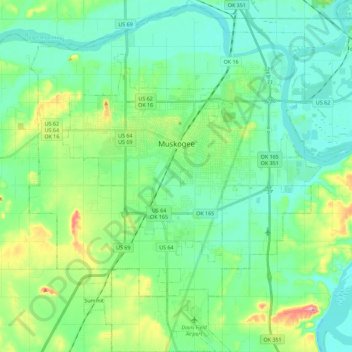
Nombre: Mapa topográfico Muskogee, altitud, relieve.
Lugar: Muskogee, Muskogee County, Oklahoma, United States (35.63865 -95.46477 35.82257 -95.27636)
Altitud media: 176 m
Altitud mínima: 145 m
Altitud máxima: 272 m
Gracias por apoyar a este sitio ❤️
Haz una donación
Haz una donación