
Gracias por apoyar a este sitio ❤️
Haz una donación
Haz una donación
Mapa topográfico Brumley Gap
Haga clic en el mapa para ver la altitud.
Gracias por apoyar a este sitio ❤️
Haz una donación
Haz una donación
Acerca de este mapa
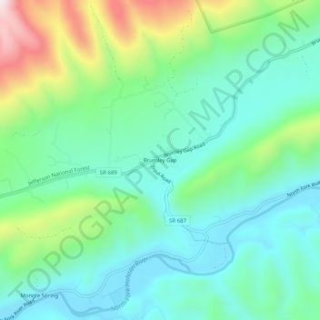
Nombre: Mapa topográfico Brumley Gap, altitud, relieve.
Lugar: Brumley Gap, Washington County, Virginia, United States (36.78205 -82.04680 36.82205 -82.00680)
Altitud media: 602 m
Altitud mínima: 441 m
Altitud máxima: 1 032 m
Gracias por apoyar a este sitio ❤️
Haz una donación
Haz una donación
Otros mapas topográficos
Haga clic en un mapa para ver su topografía, su altitud y su relieve.
Gracias por apoyar a este sitio ❤️
Haz una donación
Haz una donación
Clinch Mountain
United States > Virginia > Washington County
For its entire length, Clinch Mountain has only one true gap through which the ridge is completely sliced in half and continues as Clinch Mountain on either side, divided by Big Moccasin Creek. It is named Moccasin Gap and runs between Weber City and Gate City, Virginia. The Norfolk Southern Railway and U.S.…
Altitud media: 618 m