
Mapa topográfico Adimali
Mapa interactivo
Haga clic en el mapa para ver la altitud.
Acerca de este mapa
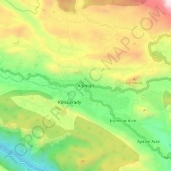
Nombre: Mapa topográfico Adimali, altitud, relieve.
Lugar: Adimali, Devikulam, Idukki District, Kerala, 685561, India (9.97443 76.91546 10.05443 76.99546)
Altitud media: 786 m
Altitud mínima: 177 m
Altitud máxima: 1 633 m
Adimaly generally has a cool climate throughout the year, typical of the higher altitudes, though not as cold as Munnar. Temperatures rarely exceed 26 degrees and never drop below 10 degrees as it usually stays around 17-24 degrees. Though December–January are comparatively cooler than other months. Adimaly is a place with heavy rainfall mostly throughout the year and it is heaviest during the June–September season of southwest monsoon. Rains in Adimaly sometimes continue for hours or even days without any dry spell, which may bring the town to a standstill. New residents frequently relocate to Adimaly, owing to its atmosphere and surroundings. This is evident considering the abrupt increase in population both within the town and nearby areas in the recent past.
Otros mapas topográficos
Haga clic en un mapa para ver su topografía, su altitud y su relieve.
Munnar Town
India > Kerala > Devikulam > Munnar
Munnar Town, Munnar, Devikulam, Idukki District, Kerala, 685612, India
Altitud media: 1 587 m
Chithirapuram
Chithirapuram, Devikulam, Idukki District, Kerala, 685565, India
Altitud media: 1 063 m
Pallivasal
Pallivasal, Devikulam, Idukki District, Kerala, 685565, India
Altitud media: 1 305 m