
Mapa topográfico Colachel
Mapa interactivo
Haga clic en el mapa para ver la altitud.
Colachel
The town is located on the western coastal side of Kanyakumari District and falls in the coordinates of 8°09′N 77°08′E / 8.15°N 77.14°E / 8.15; 77.14. The average elevation of the town is 25 meters (82 ft) above Mean Sea Level (MSL). Town is mostly characterized by a flat terrain with a few areas in the northwest region having elevation difference with other parts of the town. Generally the town is sloped gently from North to south direction and also sloping in a radial direction towards centre portion of the town from east and west directions.
Acerca de este mapa
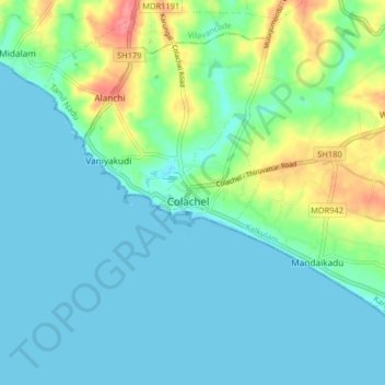
Nombre: Mapa topográfico Colachel, altitud, relieve.
Lugar: Colachel, Kalkulam, Kanniyakumari, Tamil Nadu, 629251, India (8.13527 77.21192 8.21527 77.29192)
Altitud media: 16 m
Altitud mínima: -1 m
Altitud máxima: 72 m