
Gracias por apoyar a este sitio ❤️
Haz una donación
Haz una donación
Mapa topográfico Montebello
Haga clic en el mapa para ver la altitud.
Gracias por apoyar a este sitio ❤️
Haz una donación
Haz una donación
Acerca de este mapa
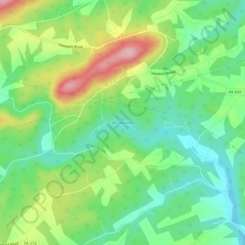
Nombre: Mapa topográfico Montebello, altitud, relieve.
Lugar: Montebello, Perry County, Pennsylvania, United States (40.40814 -77.09359 40.44814 -77.05359)
Altitud media: 185 m
Altitud mínima: 117 m
Altitud máxima: 305 m
Gracias por apoyar a este sitio ❤️
Haz una donación
Haz una donación
Otros mapas topográficos
Haga clic en un mapa para ver su topografía, su altitud y su relieve.
Gracias por apoyar a este sitio ❤️
Haz una donación
Haz una donación
Blain
United States > Pennsylvania > Perry County
According to the United States Census Bureau, the borough has a total area of 0.3 square miles (0.78 km2), all land. Population is 286 (2000). Its highest point is Conegeuege Mountain (1872 feet); the elevation is 750 feet on average.
Altitud media: 227 m
Gracias por apoyar a este sitio ❤️
Haz una donación
Haz una donación
Gracias por apoyar a este sitio ❤️
Haz una donación
Haz una donación