
Mapa topográfico Blatten
Mapa interactivo
Haga clic en el mapa para ver la altitud.
Blatten
Blatten lies in the Lötschental valley south of the Bernese Alps. The municipality is located in the Westlich Raron district, and is the highest inhabited part of the Lötschental valley at an elevation of 1,540 m (5,050 ft). It consists of the village of Blatten and the hamlets of Eisten, Ried and Weissenried. At the head of the road up the valley, Fafleralp is the site of a well known hotel.
Acerca de este mapa
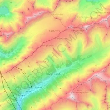
Nombre: Mapa topográfico Blatten, altitud, relieve.
Lugar: Blatten, Westlich Raron, Wallis, 3919, Switzerland (46.38912 7.76850 46.49825 7.96555)
Altitud media: 2 536 m
Altitud mínima: 1 267 m
Altitud máxima: 3 905 m
Otros mapas topográficos
Haga clic en un mapa para ver su topografía, su altitud y su relieve.