
Mapa topográfico Wayne County
Mapa interactivo
Haga clic en el mapa para ver la altitud.
Acerca de este mapa
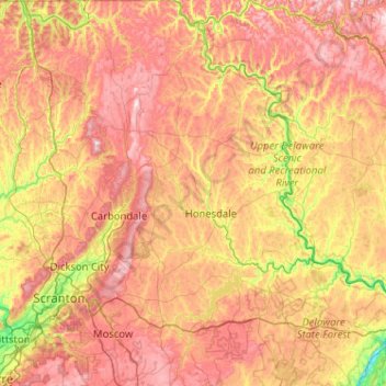
Nombre: Mapa topográfico Wayne County, altitud, relieve.
Lugar: Wayne County, Pennsylvania, United States (41.23232 -75.50581 41.99950 -75.04361)
Altitud media: 436 m
Altitud mínima: 112 m
Altitud máxima: 800 m
The highest elevation in the county, 2,659 ft (810 m), is the summit of Mount Ararat in Orson. Two other summits at the north end of the same ridge also exceed 2,640 ft (800 m) in elevation. The county's lowest point, at approximately 680 ft (210 m) above sea level, is along the Delaware, near Wayne County's border with Pike County, Pennsylvania.