
Haz una donación
Mapa topográfico Atlangatepec
Haga clic en el mapa para ver la altitud.
Haz una donación
Acerca de este mapa
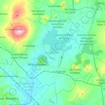
Nombre: Mapa topográfico Atlangatepec, altitud, relieve.
Lugar: Atlangatepec, Tlaxcala, Mexico (19.48939 -98.25232 19.60430 -98.10134)
Altitud media: 2 549 m
Altitud mínima: 2 462 m
Altitud máxima: 2 890 m
Haz una donación
Otros mapas topográficos
Haga clic en un mapa para ver su topografía, su altitud y su relieve.
Malinche
Mexico > Tlaxcala > Teolocholco
On lower slopes are farmlands which grow mostly field "dent" corn and forests which transition from alders and various types of oak to Montezuma pines and sacred firs with increasing elevation. The upper slopes are zacatonal. The summit is covered by snow part of the year and is considered to be the coldest…
Altitud media: 3 911 m
Tlaxcala City
Mexico > Tlaxcala > Municipio de Tlaxcala
The city is located in the central Mexican highlands 2,239 metres (7,346 feet) above sea level, in a valley of the same name, from which the Popocatépetl and Iztaccíhuatl volcanoes can be seen in the distance. The main elevations in the municipality are El Cerro Ostol at 2,460 metres (8,070 feet) and El…
Altitud media: 2 414 m