
Mapa topográfico Land Between the Lakes National Recreation Area
Mapa interactivo
Haga clic en el mapa para ver la altitud.
Acerca de este mapa
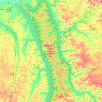
Nombre: Mapa topográfico Land Between the Lakes National Recreation Area, altitud, relieve.
Altitud media: 146 m
Altitud mínima: 92 m
Altitud máxima: 246 m
The United States Army Corps of Engineers constructed a dam on the Cumberland, producing another lake. It was planned to be at the same elevation as Kentucky Lake, and the two rivers were to be connected by a canal that did not require locks. This project was intended to lessen the shipping distances for goods going from the Cumberland Valley to ports on the Gulf of Mexico, thus increasing their profitability.
Otros mapas topográficos
Haga clic en un mapa para ver su topografía, su altitud y su relieve.
Cadiz
United States > Kentucky > Trigg County
Cadiz, Trigg County, Kentucky, United States
Altitud media: 141 m
Canton
United States > Kentucky > Trigg County
Canton, Trigg County, Kentucky, United States
Altitud media: 122 m
Rockcastle
United States > Kentucky > Trigg County > Rockcastle
Rockcastle, Trigg County, Kentucky, United States
Altitud media: 117 m