
Haz una donación
Mapa topográfico Joshua Tree National Park
Haga clic en el mapa para ver la altitud.
Haz una donación
Joshua Tree National Park
Joshua Tree National Park is an American national park in southeastern California, east of San Bernardino and Los Angeles and north of Palm Springs. It is named after the Joshua trees (Yucca brevifolia) native to the Mojave Desert. Originally declared a national monument in 1936, Joshua Tree was redesignated as a national park in 1994 when the U.S. Congress passed the California Desert Protection Act. Encompassing a total of 795,156 acres (1,242.4 sq mi; 3,217.9 km2) – slightly larger than the state of Rhode Island – the park includes 429,690 acres (671.4 sq mi; 1,738.9 km2) of designated wilderness. Straddling San Bernardino and Riverside Counties, the park includes parts of two deserts, each an ecosystem whose characteristics are determined primarily by elevation: the higher Mojave Desert and the lower Colorado Desert. The Little San Bernardino Mountains traverse the southwest edge of the park.
Haz una donación
Acerca de este mapa
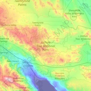
Nombre: Mapa topográfico Joshua Tree National Park, altitud, relieve.
Lugar: Joshua Tree National Park, California, United States (33.67019 -116.45803 34.12934 -115.26219)
Altitud media: 639 m
Altitud mínima: -71 m
Altitud máxima: 2 612 m
Haz una donación
Otros mapas topográficos
Haga clic en un mapa para ver su topografía, su altitud y su relieve.
San Francisco Bay Area
United States > California > San Francisco
The San Francisco Bay Area is characterized by a diverse and dynamic topography shaped by geological processes over millions of years. This region features a combination of coastal plains, steep hills, and rugged mountains, all influenced by the tectonic activity associated with the nearby San Andreas Fault…
Altitud media: 113 m
Santa Cruz Mountains
United States > California > Santa Clara County
The Santa Cruz Mountains are a region of great biological diversity, encompassing cool, moist coastal ecosystems as well as warm, dry chaparral. Much of the area in the Santa Cruz mountains is considered temperate rainforest. In valleys and moist ocean-facing slopes some of the southernmost coast redwoods…
Altitud media: 230 m
Crescent City
United States > California > Del Norte County
The topography of the sea floor surrounding Crescent City has the effect of focusing tsunamis. According to researchers at Humboldt State University and the University of Southern California, the city experienced tsunami conditions 31 times between the years 1933 and 2008. Although many of these incidents were…
Altitud media: 31 m
Haz una donación
Haz una donación
El Dorado Hills
United States > California > El Dorado County > Cameron Park
El Dorado Hills (EDH), as defined by the 2010 census-designated place (CDP), is at the western border of El Dorado County, between the City of Folsom and the unincorporated community of Cameron Park. The northern limits of the CDP are Folsom Lake and the South Fork of the American River, where river rafters…
Altitud media: 254 m
San Diego
United States > California > San Diego County > San Diego
The climate in San Diego, like most of Southern California, often varies significantly over short geographical distances, resulting in microclimates. In San Diego, this is mostly because of the city's topography (the Bay, and the numerous hills, mountains, and canyons). Frequently, particularly during the "May…
Altitud media: 57 m
Haz una donación
Arrowbear Lake
United States > California > San Bernardino County > Running Springs
Arrowbear Lake is an unincorporated community in San Bernardino County, California, United States. Its altitude is 6,086 feet (1,855 m) in the San Bernardino Mountains. It is located east of Running Springs along Highway 18 in the San Bernardino National Forest, a mountain community with a population of 736 in…
Altitud media: 1 928 m
Coachella Valley
United States > California > Riverside County > Palm Desert
The area is surrounded on the southwest by the Santa Rosa Mountains, by the San Jacinto Mountains to the west, the Little San Bernardino Mountains to the east and San Gorgonio Mountain to the north. These mountains peak at around 11,000 feet (3,400 m) and tend to average between 5,000 and 7,000 feet (1,500 and…
Altitud media: 72 m
Haz una donación
Santa Monica Mountains
United States > California > Los Angeles County > Unincorporated Santa Monica Mountains
On January 17, 2007, an unusually cold storm brought snow in the Santa Monica Mountains. The hills above Malibu picked up three inches (eight centimeters) of snow - the first measurable snow in fifty years. Snow was reported on Boney Peak in the winter of 2005; and in March 2006, snow also fell on the summit…
Altitud media: 304 m
Haz una donación
Haz una donación
Mount Williamson
United States > California > Inyo County
Mount Williamson, at an elevation of 14,379 feet (4,383 m), is the second-highest mountain in both the Sierra Nevada range and the state of California, and the sixth-highest peak in the contiguous United States.
Altitud media: 3 821 m
Haz una donación
Haz una donación
Mount Baden-Powell
United States > California > Los Angeles County
At 9,407 feet (2,867 m) in elevation, Mount Baden-Powell is traditionally considered to be the 5th highest peak of the San Gabriel Range; however it is the second highest peak in the range with more than 1,000 feet (300 m) of prominence, and is the highest peak not part of the Mount San Antonio massif.
Altitud media: 2 429 m
Haz una donación
Haz una donación
Haz una donación
Mount Shasta
United States > California > Siskiyou County
Mount Shasta (Shasta: Waka-nunee-Tuki-wuki; Karuk: Úytaahkoo) is a potentially active volcano at the southern end of the Cascade Range in Siskiyou County, California. At an elevation of 14,179 feet (4,321.8 meters), it is the second-highest peak in the Cascades and the fifth-highest in the state. Mount Shasta…
Altitud media: 3 717 m
San Francisco Bay Area
United States > California > San Francisco
The borders of the San Francisco Bay Area are not officially delineated, and the unique development patterns influenced by the region's topography, as well as unusual commute patterns caused by the presence of three central cities and employment centers located in various suburban locales, has led to…
Altitud media: 113 m
Haz una donación
Haz una donación
Haz una donación
Haz una donación
Haz una donación
Haz una donación
Haz una donación
Golden Gate Park
United States > California > San Francisco
In the 1860s, San Franciscans began to feel the need for a spacious public park similar to Central Park, which was then taking shape in New York City. Golden Gate Park was carved out of unpromising sand and shore dunes that were known as the Outside Lands, in an unincorporated area west of San Francisco's…
Altitud media: 71 m
Ramona
United States > California > San Diego County
In January 2006, Ramona Valley was designated the country's 162nd American Viticultural Area (AVA) by the Alcohol and Tobacco Tax and Trade Bureau, which recognized the area for its distinctive microclimate, elevation, and soil attributes.
Altitud media: 469 m
Haz una donación
Oakhurst
United States > California > Madera County > Oakhurst
Oakhurst is located on the Fresno River 3 miles (5 km) south-southwest of Yosemite Forks, at an elevation of 2,274 feet (693 m). Its coordinates are 37°19′41″N 119°38′58″W / 37.32806°N 119.64944°W / 37.32806; -119.64944. It is located at the junction of state highways 41 and 49, at the…
Altitud media: 837 m
Haz una donación
Cameron Park
United States > California > El Dorado County
Cameron Park is situated in an interior chaparral zone or brush zone just east of the Central Valley. It is the closest population center to the Pine Hill Ecological Reserve. Native vegetation includes an abundance of redbud and manzanita bushes, and brush in general. Where treed the native trees are primarily…
Altitud media: 390 m
Haz una donación
Golden Gate Park
United States > California > San Francisco
Conceived ostensibly for recreation, the underlying purpose of the park was housing development and the westward expansion of the city. Field engineer William Hammond Hall prepared a survey and topographic map of the park site in 1870 and became its commissioner in 1871. He was later named California's first…
Altitud media: 71 m
Haz una donación
Haz una donación
Haz una donación
Point Reyes
United States > California > Marin County
Point Reyes is bounded to the east by the San Andreas Fault, which runs directly under Tomales Bay, and is structurally dominated by the Point Reyes Syncline. The Point Reyes Peninsula is on the Pacific Plate, while the rest of Marin County land is on the North American Plate. The peninsula is a member of the…
Altitud media: 10 m
Haz una donación