
Mapa topográfico Admiralty Islands
Mapa interactivo
Haga clic en el mapa para ver la altitud.
Admiralty Islands
Manus reaches an elevation of 700 m (2,300 ft) and is volcanic in origin and probably broke through the ocean's surface in the late Miocene, 8–10 million years ago. The substrate of the island is either directly volcanic or from uplifted coral limestone.
Acerca de este mapa
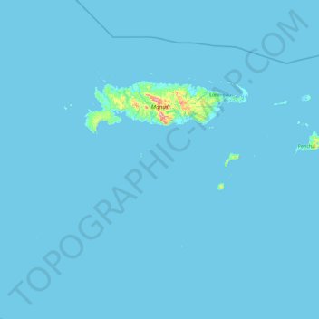
Nombre: Mapa topográfico Admiralty Islands, altitud, relieve.
Lugar: Admiralty Islands, Manus, Islands Region, Papua New Guinea (-2.90377 146.38894 -1.90289 148.20718)
Altitud media: 5 m
Altitud mínima: -3 m
Altitud máxima: 675 m
Otros mapas topográficos
Haga clic en un mapa para ver su topografía, su altitud y su relieve.