
Mapa topográfico Mathon
Mapa interactivo
Haga clic en el mapa para ver la altitud.
Acerca de este mapa
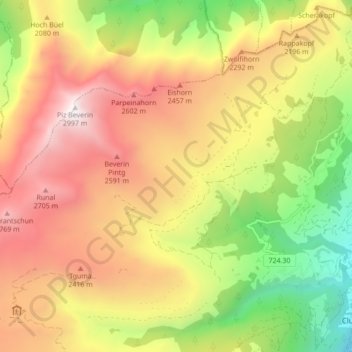
Nombre: Mapa topográfico Mathon, altitud, relieve.
Lugar: Mathon, Muntogna da Schons, Viamala, Grisons, 7433, Switzerland (46.62476 9.33704 46.65706 9.42337)
Altitud media: 1 994 m
Altitud mínima: 961 m
Altitud máxima: 2 987 m
Before 2017, the former municipality was located in the Schams sub-district, of the Hinterrhein district, after 2017 it was part of the Viamala Region.[6] The village is a haufendorf (an irregular, unplanned and quite closely packed village, built around a central square) at an elevation of 1,521 m (4,990 ft) in the center of the upper Schamserberg region.