
Gracias por apoyar a este sitio ❤️
Haz una donación
Haz una donación
Mapa topográfico Eislingen/Fils
Haga clic en el mapa para ver la altitud.
Gracias por apoyar a este sitio ❤️
Haz una donación
Haz una donación
Eislingen/Fils
The city (Stadt) of Eislingen is located in the north of the district of Göppingen, in the German state of Baden-Württemberg. Eislingen is physically located in the Fils river valley, at the mouth of the Krumm, in the central [de] and eastern foothills [de] of the Swabian Jura. Elevation above sea level in the municipal area ranges from a high of 479 meters (1,572 ft) Normalnull (NN), in the northeast, to a low of 324 meters (1,063 ft) NN on the Fils.
Gracias por apoyar a este sitio ❤️
Haz una donación
Haz una donación
Acerca de este mapa
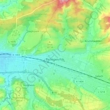
Nombre: Mapa topográfico Eislingen/Fils, altitud, relieve.
Altitud media: 369 m
Altitud mínima: 321 m
Altitud máxima: 470 m
Gracias por apoyar a este sitio ❤️
Haz una donación
Haz una donación
Otros mapas topográficos
Haga clic en un mapa para ver su topografía, su altitud y su relieve.