
Mapa topográfico Lausanne
Mapa interactivo
Haga clic en el mapa para ver la altitud.
Lausanne
The most important geographical feature of the area surrounding Lausanne is Lake Geneva (Lac Léman in French). Lausanne is built on the southern slope of the Swiss plateau, with a difference in elevation of about 500 metres (1,640 ft) between the lakeshore at Ouchy and its northern edge bordering Le Mont-sur-Lausanne and Épalinges. Lausanne boasts a dramatic panorama over the lake and the Swiss and Savoyan Alps.
Acerca de este mapa
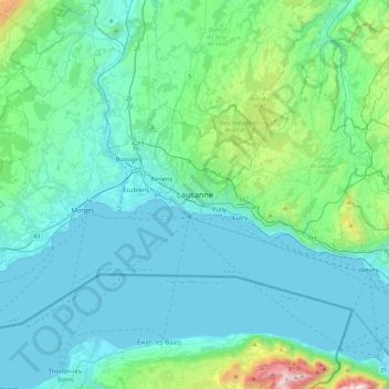
Nombre: Mapa topográfico Lausanne, altitud, relieve.
Lugar: Lausanne, District de Lausanne, Vaud, 1003, Switzerland (46.36183 6.47270 46.68183 6.79270)
Altitud media: 577 m
Altitud mínima: 367 m
Altitud máxima: 1 958 m