
Gracias por apoyar a este sitio ❤️
Haz una donación
Haz una donación
Mapa topográfico Seven Springs
Haga clic en el mapa para ver la altitud.
Gracias por apoyar a este sitio ❤️
Haz una donación
Haz una donación
Seven Springs
Seven Springs has the distinction of being, in elevation, the highest borough in Pennsylvania, at 2,530 feet (770 m). It sits along the crest of Laurel Hill, a major north–south ridge of the Allegheny Mountains.
Gracias por apoyar a este sitio ❤️
Haz una donación
Haz una donación
Acerca de este mapa
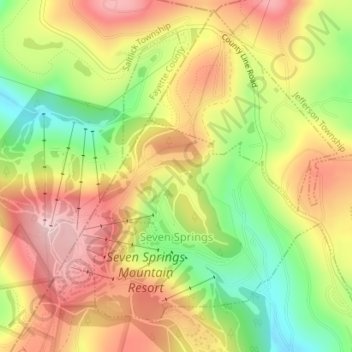
Nombre: Mapa topográfico Seven Springs, altitud, relieve.
Lugar: Seven Springs, Somerset County, Pennsylvania, United States (40.01658 -79.30551 40.03894 -79.27556)
Altitud media: 804 m
Altitud mínima: 678 m
Altitud máxima: 912 m
Gracias por apoyar a este sitio ❤️
Haz una donación
Haz una donación
Otros mapas topográficos
Haga clic en un mapa para ver su topografía, su altitud y su relieve.
Flight 93 National Memorial
United States > Pennsylvania > Somerset County > Stonycreek Township
Altitud media: 729 m
Gracias por apoyar a este sitio ❤️
Haz una donación
Haz una donación
Gracias por apoyar a este sitio ❤️
Haz una donación
Haz una donación