
Gracias por apoyar a este sitio ❤️
Haz una donación
Haz una donación
Mapa topográfico Hallbergmoos
Haga clic en el mapa para ver la altitud.
Gracias por apoyar a este sitio ❤️
Haz una donación
Haz una donación
Acerca de este mapa
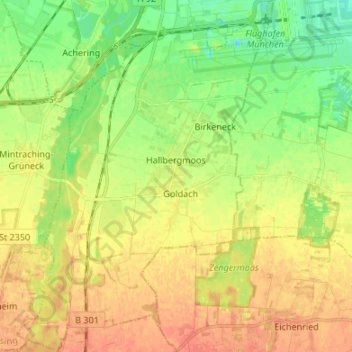
Nombre: Mapa topográfico Hallbergmoos, altitud, relieve.
Lugar: Hallbergmoos, Landkreis Freising, Bavaria, 85399, Germany (48.26952 11.68389 48.35863 11.78163)
Altitud media: 460 m
Altitud mínima: 439 m
Altitud máxima: 479 m
Gracias por apoyar a este sitio ❤️
Haz una donación
Haz una donación
Otros mapas topográficos
Haga clic en un mapa para ver su topografía, su altitud y su relieve.